You are here: Wiki>GEONETCAST Web>GEONETCastCourse_SS2010>ReferenceArchitecture>StandardizedCoverageInterfaces>MsgHritInterface (24 Sep 2010, JohannesTrame)Edit Attach
Interface for MSG HRIT Raster Data
MSG-2 data received from GEONETCast data stream is made webaccessible through OGC conform interface using Map Server. The WCS/WMS instance serves only 11 of the 12 available channels, as geotiff format can only handle differentchannels with equal resolutions, thus the 12th band (high resolution visible light) cannot be included (resolution 1 kilometer). The raw MSG-2 data received from GEONETCast is transformed by the MsgHritScheduler into geotiff format, stored on the interface instance and can thereby be directly served through WCS as well as WMS. We decided to use transform the raw data into geotiff beforehand and for redudant storage, because:- we can apply indexing strategies on the interface instance
- on-the-fly transformation of the raw MSG data (which is in a proprietary format encoded) into common dataformats like geotiff is very costly:
For example: to transform 11 channels of msg raw data for a single timestamp into one geotiff takes 3-5minutes on our machine.
MSG Product Description
MSG = Meteosat Second Generation data (MSG) for meteorological analysis [Schmetz et al. 2002]. MSG-2 data consists of 12 channels of which 11 channels have a resolution of 3 kilometers and one high resolution visible light at 1kilometers. The 12 channels are collected from visible to infrared spectrum. Every 6 hours new data is distrubed by the satelitte dissemination system (00h,06h,12h,18h). Channel 1: vis 0.6 µmChannel 2: vis 0.8 µm
Channel 3: ir 1.6 µm
Channel 4: ir 3.9 µm
Channel 5: wv 6.2 µm
Channel 6: wv 7.3 µm
Channel 7: ir 8.7 µm
Channel 8: ir 9.7 µm
Channel 9: ir 10.8 µm
Channel 10: ir 10.0 µm
Channel 11: ir 13.4 µm Schmetz, J., Pili, P., Tjemkes, S., Just, D., Kerkmann, J., Rota, S., and Ratier, A. (2002).
An introduction to meteosat second generation (msg). Bulletin of the American Meteorological
Society, 83(7):977–992.
System Specifications
Technical setup
For first prototyping we used a virtual maschine in order to assess performance requirments for later operational mode.- OS: Windows Server 2008 R2 Enterprise - 64Bit
- CPU - Intel Xeon CPU @2.66GHZ
- 2GB RAM
- 120GB Storage
Software
- Map Server allows us to serve thedata through WCS interface (data access) as well as WMS interface (data portrayal). Users are thereby able to inspect the data (using WMS interface) without downloading
- The MsgHritScheduler transforms the MSG raw data into geotiff and adds each geotiff as a new time-coverage to the mapserver database
Maintainance
Infrastructure Administrator
The infrastructure administrator may need to (re)start the server because of:- necessary system (securtiy) updates
- network/system crash
Product Administrator
No maintainance tasks for the product administrator.Service Administrator
The service administrator has to do the inital configuration of mapserver (using the mapfile), configuration of the scheduler and has to keep his eyes on the running service.Use Case: WMS & WCS Client Access
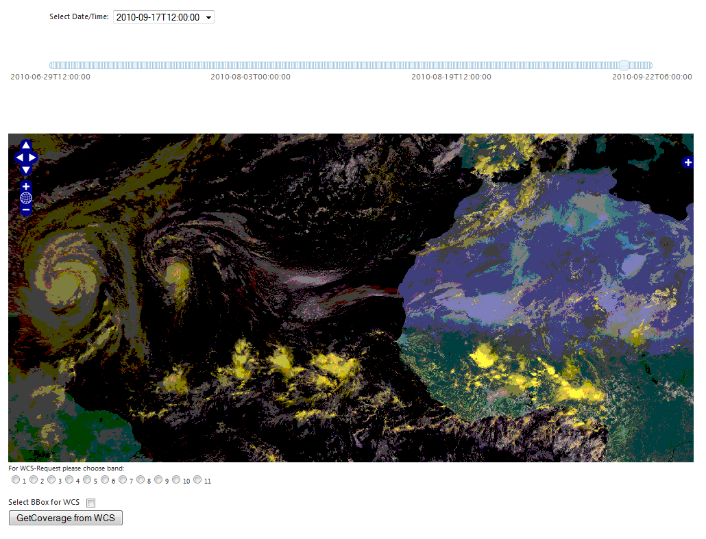
Since the lack of ExistingWcsClients we developed a simple Webclient. The browser-based application allows the user to specify the data regarding time, geographic extent and specific channel. In the given example, data of hurricane Karl in the Gulf of Mexico in September 20102 is portrayed (based on channel 1 of MSG data collected at visible spectrum). The user can now select on the map a geographic extent, of which he wants to receive data. Based on this selection, the browserbased application generates a WCS-compliant URL, which can be used to download the designated coverage from the WCS instance. The client and example GET-Requests can be found on http://gnc-wcs.uni-muenster.de/
-- JohannesTrame - 2010-09-23
| I | Attachment | Action | Size | Date | Who | Comment |
|---|---|---|---|---|---|---|
| |
msg_mapfile.zip | manage | 1 K | 23 Sep 2010 - 23:42 | UnknownUser | |
| |
screenshot_17_09_2010_12h.png | manage | 170 K | 23 Sep 2010 - 11:58 | UnknownUser |
Edit | Attach | Print version | History: r10 < r9 < r8 < r7 | Backlinks | View wiki text | Edit wiki text | More topic actions
Topic revision: r9 - 24 Sep 2010, JohannesTrame
Legal Notice | Privacy Statement
 Copyright © by the contributing authors. All material on this collaboration platform is the property of the contributing authors.
Ideas, requests, problems regarding Wiki? Send feedback
 Copyright © by the contributing authors. All material on this collaboration platform is the property of the contributing authors.
 Ideas, requests, problems regarding Wiki? Send feedback


