|
|
You are here: Wiki>Geoprocessing Web>GeoprocessingTutorials>StoreWPSOutputsInGeoserver (28 Jan 2014, EikeJuerrens)Edit Attach
How to store WPS outputs in Geoserver
Storing raster or vector data in a WMS layer
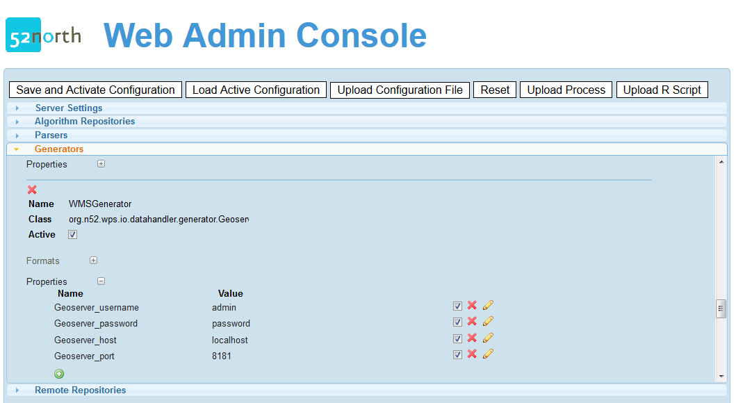
First, you will have to configure the Geoserver WMS generator. You can do this via the Admin Console: or directly in the wps_config.xml:
<Generator name="WMSGenerator"
 className="org.n52.wps.io.datahandler.generator.GeoserverWMSGenerator"
 active="true">
 <Format mimetype="application/WMS" />
 <Property name="Geoserver_username" active="true">admin</Property>
 <Property name="Geoserver_password" active="true">password</Property>
 <Property name="Geoserver_host" active="true">localhost</Property>
 <Property name="Geoserver_port" active="true">8181</Property>
 </Generator>
The following are the supported data bindings of the Geoserver WMS generator:
!GTRasterDataBinding.class
!ShapefileBinding.class
!GeotiffBinding.class
!GTVectorDataBinding.class
If you create a new process, make sure one of these binding is supported as output.The mime type "application/WMS" should appear in the ProcessDescription after you activated the generator.
Storing raster data in a WCS layer
First, you will have to configure the Geoserver WCS generator. You can do this via the Admin Console (see WMS generator),or directly in the wps_config.xml:<Generator name="WCSGenerator" className="org.n52.wps.io.datahandler.generator.GeoserverWCSGenerator" active="true"> <Format mimetype="application/WCS" /> <Property name="Geoserver_username" active="true">admin</Property> <Property name="Geoserver_password" active="true">password</Property> <Property name="Geoserver_host" active="true">localhost</Property> <Property name="Geoserver_port" active="true">8181</Property> </Generator>The following are the supported data bindings of the Geoserver WCS generator:
!GTRasterDataBinding.class
!GeotiffBinding.class
If you create a new process, make sure one of these binding is supported as output.The mime type "application/WCS" should appear in the ProcessDescription after you activated the generator.
Storing vector data in a WFS layer
First, you will have to configure the Geoserver WFS generator. You can do this via the Admin Console (see WMS generator),or directly in the wps_config.xml:<Generator name="WFSGenerator" className="org.n52.wps.io.datahandler.generator.GeoserverWFSGenerator" active="true"> <Format mimetype="application/WFS" /> <Property name="Geoserver_username" active="true">admin</Property> <Property name="Geoserver_password" active="true">password</Property> <Property name="Geoserver_host" active="true">localhost</Property> <Property name="Geoserver_port" active="true">8181</Property> </Generator>The following are the supported data bindings of the Geoserver WCS generator:
!GTVectorDataBinding.classIf you create a new process, make sure this binding is supported as output.The mime type "application/WFS" should appear in the ProcessDescription after you activated the generator.
Configuring output storing in Geoserver in the ExecuteRequest
In order to store the process output in a Geoserver instance, the ResponseForm element of the ExecuteRequest must look like the following (similar for WMS and WCS):<wps:ResponseForm> <wps:ResponseDocument> <wps:Output mimeType="application/WFS"> <ows:Identifier>result</ows:Identifier> <ows:Title>result</ows:Title> <ows:Abstract>result</ows:Abstract> </wps:Output> </wps:ResponseDocument> </wps:ResponseForm> </wps:Execute>If you are using the Client API, the following lines will create an ExecuteRequest accordingly:
ExecuteRequestBuilder executeBuilder = new org.n52.wps.client.ExecuteRequestBuilder(
 processDescription);

executeBuilder.setMimeTypeForOutput("application/WFS", process_output);
In the following you can see a ResponseDocument, where the layer name (ResourceID) and the WFS GetCapabilities link is stated:
<?xml version="1.0" encoding="UTF-8"?>
<ns:ExecuteResponse xmlns:ns="http://www.opengis.net/wps/1.0.0" xmlns:xsi="http://www.w3.org/2001/XMLSchema-instance" xsi:schemaLocation="http://www.opengis.net/wps/1.0.0
http://schemas.opengis.net/wps/1.0.0/wpsExecute_response.xsd" serviceInstance="http://localhost:8080/wps/WebProcessingService?REQUEST=GetCapabilities&SERVICE=WPS" xml:lang="en-US" service="WPS" version="1.0.0">
   <ns:Process ns:processVersion="1.1.0">
      <ns1:Identifier xmlns:ns1="http://www.opengis.net/ows/1.1">org.n52.wps.server.algorithm.SimpleBufferAlgorithm</ns1:Identifier>
      <ns1:Title xmlns:ns1="http://www.opengis.net/ows/1.1">org.n52.wps.server.algorithm.SimpleBufferAlgorithm</ns1:Title>
   </ns:Process>
   <ns:Status creationTime="2013-06-12T11:27:22.606+02:00">
      <ns:ProcessSucceeded>Process successful</ns:ProcessSucceeded>
   </ns:Status>
   <ns:ProcessOutputs>
      <ns:Output>
         <ns1:Identifier xmlns:ns1="http://www.opengis.net/ows/1.1">result</ns1:Identifier>
         <ns1:Title xmlns:ns1="http://www.opengis.net/ows/1.1">result</ns1:Title>
         <ns:Data>
            <ns:ComplexData mimeType="application/WFS"><![CDATA[<?xml version="1.0" encoding="UTF-8"?><OWSResponse type="WFS"><ResourceID>N52:Shape_73e0415e-e973-4ee9-a070-9b0e42222a3b3859765591135812303</ResourceID>
<GetCapabilitiesLink>http://geoprocessing.demo.52north.org:8080/geoserver/wfs?Service=WFS&Request=GetCapabilities&Version=1.1.0</GetCapabilitiesLink></OWSResponse>]]></ns:ComplexData>
         </ns:Data>
      </ns:Output>
   </ns:ProcessOutputs>
</ns:ExecuteResponse>
The follwing image shows an example WPS output as WFS layer (OpenLayers-style):
 This is the respective link.


| I | Attachment |
Action | Size | Date | Who | Comment |
|---|---|---|---|---|---|---|
| |
20061023wpsgeoserver.zip | manage | 6 MB | 23 Oct 2006 - 13:16 | UnknownUser | WPS geoserver integration binaries. |
| |
admin_console_wms_generator.png | manage | 33 K | 14 Jun 2013 - 07:36 | BenjaminPross | |
| |
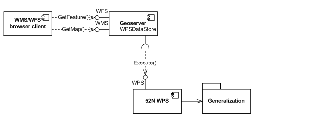
Picture1.png | manage | 8 K | 20 Oct 2006 - 18:22 | UnknownUser | Service architecture for integration of geoserver and 52n WPS |
| |
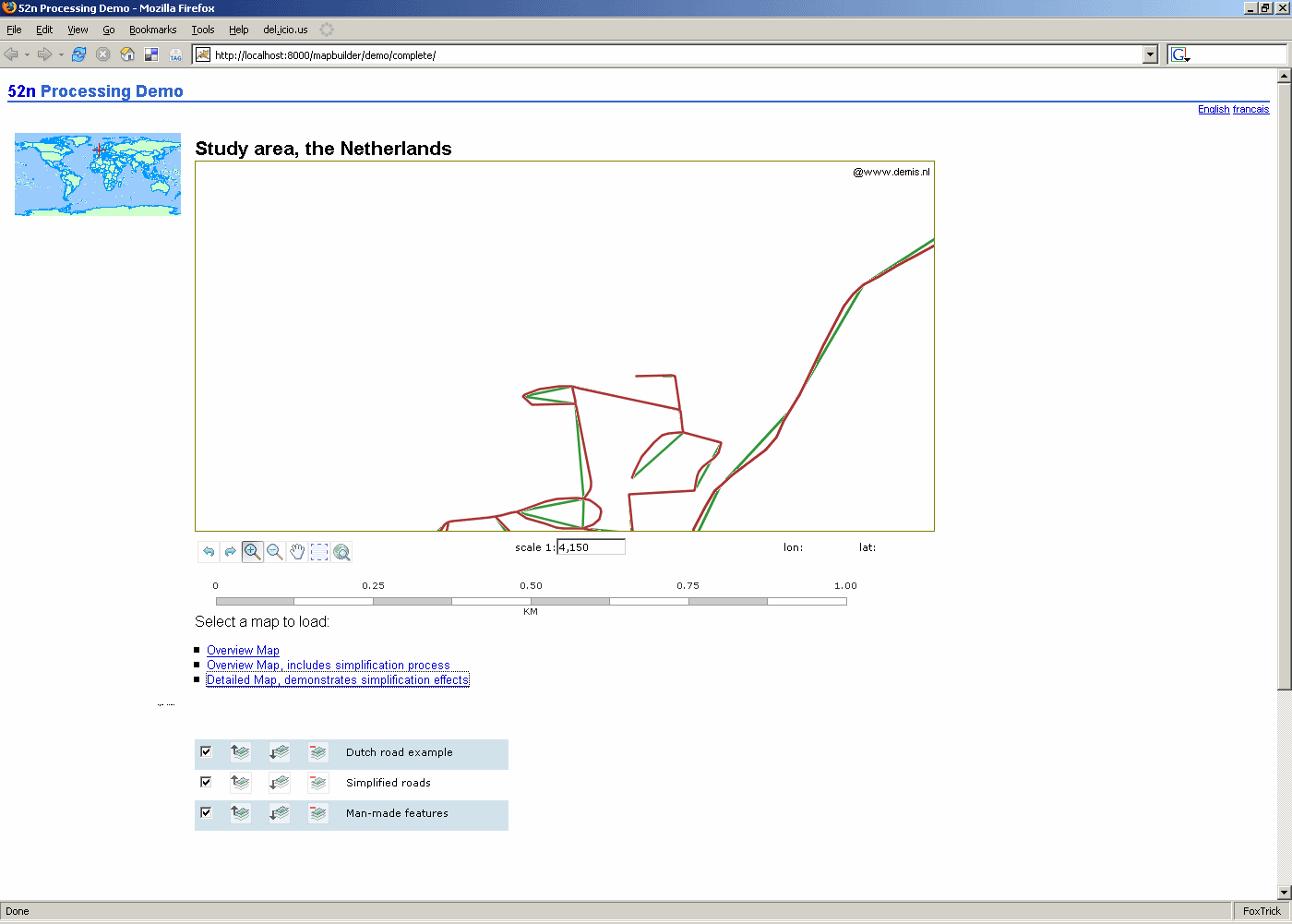
prototype_mapbuilderWPS.gif | manage | 35 K | 23 Oct 2006 - 12:08 | UnknownUser | Mapbuilder prototype with processed data.... |
| |
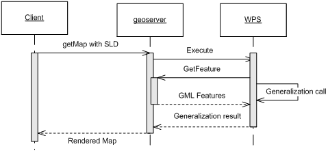
sequence.png | manage | 7 K | 23 Oct 2006 - 09:29 | UnknownUser | Sequence diagram |
| |
wps_output_as_geoserver_wfs_layer.png | manage | 20 K | 14 Jun 2013 - 07:36 | BenjaminPross |
Edit | Attach | Print version | History: r9 < r8 < r7 < r6 | Backlinks | View wiki text | Edit wiki text | More topic actions
Topic revision: r8 - 28 Jan 2014, EikeJuerrens
- Toolbox
-
 Users
Users
-
 Index
Index
-
 Search
-
 Changes
-
 Notifications
-
 RSS Feed
-
 Preferences
- Webs
-
 AI_GEOSTATS
- Documentation
- GEONETCAST
- Geoprocessing
- Geostatistics
- Metadata
- Projects
- Sandbox
- Security
- Semantics
- SensorWeb
- System
- V3d
- Categories
Legal Notice | Privacy Statement
 Copyright © by the contributing authors. All material on this collaboration platform is the property of the contributing authors.
Ideas, requests, problems regarding Wiki? Send feedback
Ideas, requests, problems regarding Wiki? Send feedback